Forest Analytics
with Geospatial Technology
Harness AI, Machine Learning, and Large-Scale Data
to Monitor and Protect Your Green Assets
Our Features
Empowering you with prompt data and actionable analytics
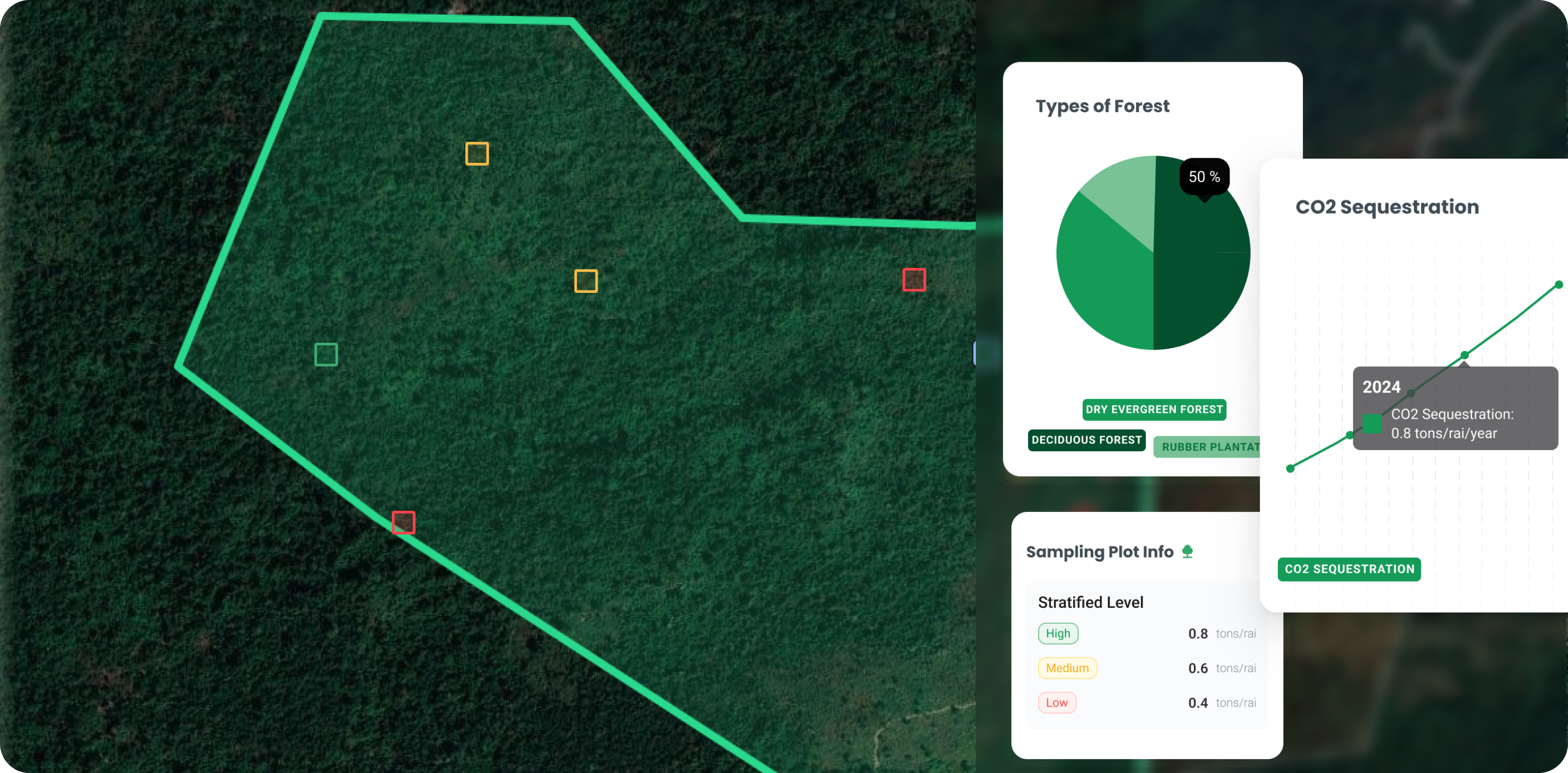
Precisely measure carbon stocks and estimate carbon credits with an intuitive visualization. Our ML-driven engine analyzes satellite imagery to help you reduce greenhouse gas emissions and capitalize on carbon market opportunities.
 Explore Our Projects
From national parks to community forests, discover how we collaborate with stakeholders to safeguard natural
habitats. Learn about real-world results and the transformative impact of our cutting-edge technology.
Explore Our ProjectsKhao Yai National Park
Nakhon RatchasimaLocated in Nakhon Ratchasima, Thailand, this UNESCO World Heritage site is home to rich biodiversity. By leveraging Smart Forest, park rangers and local communities can identify
deforestation hotspots, monitor wildlife habitats *, and ensure the long-term health of this treasured ecosystem.
Explore Our Projects
From national parks to community forests, discover how we collaborate with stakeholders to safeguard natural habitats. Learn about real-world results and the transformative impact of our cutting-edge technology.
Explore Our Projects
Khao Yai National Park
Nakhon Ratchasima
Located in Nakhon Ratchasima, Thailand, this UNESCO World Heritage site is home to rich biodiversity. By leveraging Smart Forest, park rangers and local communities can identify
deforestation hotspots, monitor wildlife habitats *, and ensure the long-term health of this treasured ecosystem.
Why Smart Forest?Value Proposition of Smart Forest Platform
 Decentralized ManagementLocal officers and community members can collectively monitor forests, making protection efforts more inclusive
and adaptable to each region’s needs.
Decentralized ManagementLocal officers and community members can collectively monitor forests, making protection efforts more inclusive
and adaptable to each region’s needs. Reduce Time & CostEfficiently capture ground data and imagery for large-scale analysis. Cut down on labor-intensive field surveys
and accelerate your decision-making.
Reduce Time & CostEfficiently capture ground data and imagery for large-scale analysis. Cut down on labor-intensive field surveys
and accelerate your decision-making. PrecisePinpoint critical areas for reforestation or risk mitigation through highly accurate AI-driven satellite and
drone imagery interpretation.
PrecisePinpoint critical areas for reforestation or risk mitigation through highly accurate AI-driven satellite and
drone imagery interpretation. User-Friendly DesignOur intuitive interface ensures everyone—regardless of technical expertise—can participate in protecting and
restoring forested lands.
User-Friendly DesignOur intuitive interface ensures everyone—regardless of technical expertise—can participate in protecting and
restoring forested lands. ReliableTransparent data and traceable carbon credits build trust among stakeholders, from forest owners to
sustainability investors.
ReliableTransparent data and traceable carbon credits build trust among stakeholders, from forest owners to
sustainability investors.
Why Smart Forest?
Value Proposition of Smart Forest Platform
Decentralized Management
Local officers and community members can collectively monitor forests, making protection efforts more inclusive
and adaptable to each region’s needs.
Reduce Time & Cost
Efficiently capture ground data and imagery for large-scale analysis. Cut down on labor-intensive field surveys
and accelerate your decision-making.
Precise
Pinpoint critical areas for reforestation or risk mitigation through highly accurate AI-driven satellite and
drone imagery interpretation.
User-Friendly Design
Our intuitive interface ensures everyone—regardless of technical expertise—can participate in protecting and
restoring forested lands.
Reliable
Transparent data and traceable carbon credits build trust among stakeholders, from forest owners to
sustainability investors.

Knowledge Center for Geospatial and Remote Sensing Data
Stay informed with our blog posts and latest news on Geospatial and Remote Sensing technology. Discover best
practices, success stories, and expert insights that will elevate your forest management strategy.
See all >Contact Us
Join us in the new era of Green Area
Questions or requests for Smart Forest? Our team is here to help. Tell us a little about your needs so we can connect you with the right experts.
Visits Us
VARUNA (THAILAND) CO., LTD.
304 Vanit Place Aree (Building A), 25th Floor, Unit 2501, Phaholyothin Road, Samsen Nai, Phaya Thai, Bangkok
Write to Us
varuna.contact@varuna.co.th
Contact Us
02-078-4058